Humberto, the eighth named storm of the 2025 Atlantic hurricane season, strengthened into a hurricane late Thursday night, but it is not expected to impact South Florida, meteorologists say.
Where is Humberto?
As of 11 p.m. Sept. 26, Humberto is located about 390 miles northeast of the Northern Leeward Islands, moving northwestward at 7 mph with maximum sustained winds of 145 mph.
Humberto becomes a hurricane
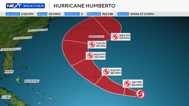
Humberto, like the other two hurricanes of the season, rapidly intensified Friday to a Category 4 hurricane as it began a turn to the north, where Bermuda remained on alert.
Tropical disturbance over Hispaniola
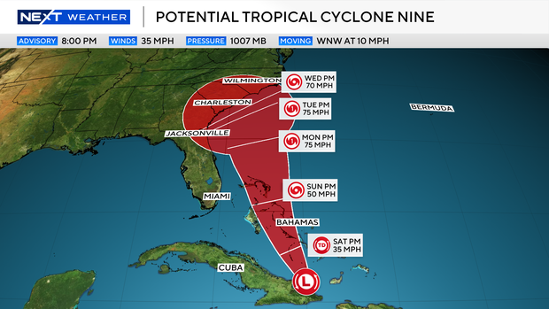
The tropical disturbance north of Haiti and the Dominican Republic has yet to form a closed center, so it is not yet classified as a tropical depression or tropical storm.
Despite this, the National Hurricane Center triggered its relatively new protocol of initiating advisories before a storm actually develops. They do this only when a system that has yet to form will threaten land within 72 hours and they want to get information out to the public as soon as possible. They call it a potential tropical cyclone.
A tropical cyclone is just the parent name of a tropical depression, a tropical storm, and a hurricane. They are all tropical cyclones.
So now that we have our familiar cone, state and local officials can coordinate with emergency managers on what protocols need to be activated.
For you and me, it lets us know where the center of the storm will pass and despite South Florida not being in the cone, we will experience the usual marine hazards.
What we don’t yet know is how close and to a lesser extent, how strong a future Imelda will have when it parallels Florida’s east coast.
A closer pass could potentially bring us the system’s outermost rain bands on Sunday. This is the less likely scenario, and I’m expecting more of the usual indirect marine hazards, such as rough boating and a higher threat of rip currents.
As far as where it ends up, the models have been consistent on taking this system up to the Carolinas early next week as the only hurricane landfall of the season.
As always, keep checking back with us for any changes. You can do that here or during our newscasts and stream. Always have your hurricane plan up to date and you won’t have to worry about it if a storm were to threaten our area.
2025 Atlantic hurricane season
NEXT Weather ![]()
The National Oceanic and Atmospheric Administration, or NOAA, forecast an above-normal hurricane season this year, predicting there will be between 13 and 18 named storms. Five to nine of those are expected to become hurricanes.
Erin was the first, and so far only, storm to become a hurricane this season. Erin didn’t make landfall, but at its peak grew to a ferocious Category 5, and it caused strong winds, dangerous rip currents and flooding along parts of the East Coast.
Historically, on average, hurricane and tropical storm activity peaks on Sept. 10, but this year has been quieter than expected when it comes to tropical systems in the Atlantic.
Source link

