The Lee Fire burning in Western Colorado has begun racing south after winds shifted away from the town of Meeker on Friday, prompting officials to declare new evacuation zones.
CBS 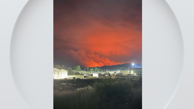
As of Saturday morning, the Lee Fire to the southwest of Meeker had burned 88,877 acres by Saturday morning. However, that number grew to 92,047 by the afternoon. It remains 0% contained.
To the southeast of town, the Elk Fire is 8% contained and has burned 14,635 acres thus far. Officials said over 1,200 personnel are working on the Lee and Elk Fires combined. The Lee Fire is now the sixth-largest wildfire in Colorado since 2001.
Meeker’s evacuation status was downgraded to “ready” Friday night as the winds shifted away from the town. However, due to the winds changing direction, new evacuation zones have been declared south and west of the Lee Fire. The fire is heading southwest from Hwy 13. Rio Blanco CR 5, Piceance Creek Road, is now closed.
Rio Blanco County Sheriff’s Office 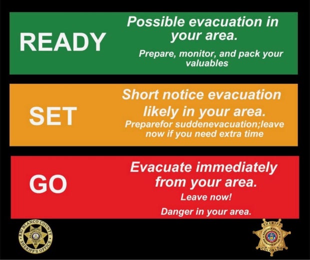
Evacuation Zones 63 and 70 to the south of the fire are now in “Go” status; residents in the area need to leave immediately. The Garfield County Sheriff’s Office said the best route out is to head south on County Road 253 (Piceance Creek Road) to Highway 13 and proceed down to Rifle. Local traffic will be allowed through this closed route.
South of the fire, along the northern edge of Garfield County, zones 80 and 81 are in “Set” status. A short-notice evacuation for these residents is likely, and officials encouraged them to be ready to leave. They suggest those who need more time to leave now. Zone 66 is now in “Ready” status, meaning there could be a possible evacuation in the area. Residents should pack their valuables, prepare, and monitor fire conditions as they change.
Although the Town of Rifle is not under evacuation orders now, authorities are evacuating the Rifle Correctional Center. According to some residents, ash and smoke can be seen as far as Rifle and Parachute.
You can find an updated list of evacuation zones and orders here.
Esri, NASA, USGS, USDA, GTAC, IRWIN, National Park Service, Fish and Wildlife Service, Bureau of Indian Affairs 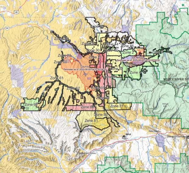
Red Cross shelters remain open at the Moffat County High School in Craig and the Church of Jesus Christ of Latter Day Saints in Rangley. An evacuation center is also available at the Fairfield Center in Meeker, and the Rio Blanco County Fairgrounds is providing an emergency shelter for evacuated livestock.
Firefighters are hoping they can keep the fire from moving east of Hwy 13, which could help serve as a fire break, but they say there’s still a long fight ahead.
“There’s still a lot of work left to be done and a lot of risk still out there for this thing to keep going,” said Operations Planning Chief Tyler Nathe. “[We’re] staying focused, and staying energized on what we’re here to do, and that’s to protect people and their property and do it safely.”
Garfield County Sheriff’s Office 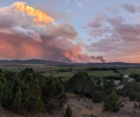
Officials said the Lee Fire has grown so large, and is burning so hot, that it’s creating its own weather. They said pyrocumulus clouds created by the intense convection, combined with moisture in the air, have reached 30,000 feet high. Nathe said the fire is creating its own winds and feeding itself.
Source link

