Hurricane forecasters were tracking three disturbances in the Atlantic Ocean Sunday afternoon, one of which is expected to briefly become the season’s fourth named storm as it moves away from the U.S.
A non-tropical area of low pressure that was located off the coast of North Carolina at 1 p.m. Sunday is expected to become a tropical storm by Monday, according to the National Hurricane Center.
Weather systems generally lie somewhere on a spectrum between fully tropical, like a hurricane, and non-tropical, like a winter storm. The differences between the two lie in how the systems form and gain power, according to the Weather Channel.
It’s not unusual for non-tropical weather systems to form over the Atlantic. Sometimes, those non-tropical systems have some chance of taking on tropical characteristics.
The system near North Carolina was moving east-northeast at 10 mph and had a 70% chance of forming into a tropical depression or storm in the next two days. It will likely run into conditions that will prevent further development after Monday, forecasters said.
If a tropical storm were to form it would be called Dexter. Three other storms have formed so far this year: Andrea, Barry and Chantal.
Tropical wave near Africa
Forecasters are also watching out for a tropical wave that’s expected to move off the west coast of Africa within the next day or two. The wave could gradually develop as it moves west-northwest across the central tropical Atlantic. Forecasters said a depression could form late in the coming week.
As of 1 p.m. Sunday, the system had a 40% chance of forming within the next week, according to the NHC.
Low pressure southeast of Carolinas
Another disturbance off the East Coast of the U.S. could develop later this week.
Forecasters said they expect an area of low pressure to form a few hundred miles southeast of the Carolinas, where some gradual strengthening is possible. As of 1 p.m. Sunday, the disturbance had a 20% chance of forming into a tropical depression or storm within the next week.
None of the disturbances pose an immediate threat to Louisiana.
Peak season
Hurricane season runs from June 1 through Nov. 30, and though the first two months came and went without much tropical activity, experts say the vast majority of storms that form in the Atlantic do so after Aug. 1.
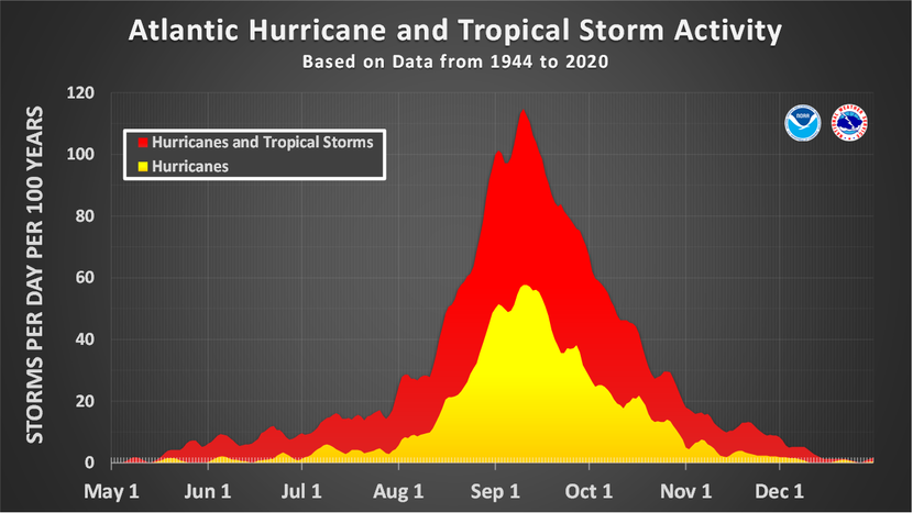
Data from 1944 to 2000 shows the busiest period for tropical storms and cyclones in the Atlantic Basin runs from mid-August through October, with Sept. 10 being the peak of hurricane season.
According to records of storms between 1944 and 2020, dating back to the start of aircraft reconnaissance, the most active part of the Atlantic hurricane season has been between mid-August and early October. Sept. 10 is the date on which the highest number of named storms have been present in the Atlantic basin, which includes the Caribbean Sea, Gulf of Mexico and Atlantic Ocean, according to the NHC.
Source link

