Tropical Storm Imelda is forecast to strengthen into a hurricane as it moves off the Southeast coast this week, kicking up dangerous surf, rip currents, coastal flooding and beach erosion from Florida through the Carolinas.
At the same time, Hurricane Humberto, which briefly exploded into a rare Category 5 storm with 160 mph winds Saturday, is now a large Category 4 hurricane. Located a few hundred miles east of Imelda, Humberto’s massive size will compound the hazards for US beaches this week, driving deadly rip currents and big waves farther north along the East Coast than Imelda alone.
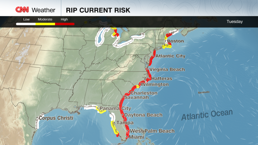
Imelda’s center is expected to stay well off the US coast – a significant change in the forecast from over the weekend – but its wide-reaching storminess will still bring wet weather to some. Localized flash flooding is possible in the coastal Carolinas through Tuesday, but forecast rainfall totals have decreased substantially to an inch or less in most areas.
Coastal flooding is also possible from Florida’s Space Coast to North Carolina’s Outer Banks, where onshore winds could push water 1 to 2 feet above normally dry ground at high tide.
The Bahamas are still enduring Imelda’s winds and heavy rain after being soaked over the weekend. Tropical storm warnings remain in effect for parts of the islands, with 4 to 8 inches of rain expected to trigger flash flooding. Storm surge of 1 to 3 feet is also possible, while eastern Cuba could see 2 to 4 inches of additional rainfall and localized mudslides in higher terrain.
As of early Monday, Imelda had sustained winds of 50 mph and was centered 265 miles east-southeast of Cape Canaveral, Florida, according to the National Hurricane Center. The storm is expected to intensify into a hurricane Tuesday as it parallels Florida’s Atlantic Coast, before making an abrupt turn eastward into open water.
That turn is thanks to Humberto: Imelda’s slower than expected northward movement means Humberto will win a tropical tug-of-war and pull Imelda away from the shoreline. This anticipated interaction between the two storms is the main reason threats of flooding rain and damaging winds are decreasing for the US compared to concerns over the weekend.
Officials in the Southeast had geared up to deal with the storm while the forecast looked more threatening. South Carolina Gov. Henry McMaster issued a state of emergency Friday, activating statewide response plans, while the City of Charleston declared a local state of emergency Saturday and began distributing sandbags and clearing storm drains. North Carolina Gov. Josh Stein also issued a state of emergency Saturday to mobilize resources.
Bermuda will get the short end of the stick from this shift in Imelda’s track and faces a rare one-two punch. Humberto is expected to pass west of the island as a Category 4 storm Monday into Tuesday, bringing bands of rain, gusty winds and dangerous surf. The Bermuda Weather Service has issued a tropical storm watch for the archipelago.
On the heels of Humberto, Imelda could track even closer to Bermuda, with potential for a direct landfall Wednesday into Thursday. Two hurricanes in a week could deliver a punishing blow, even for the seasoned and storm-tested islands.
So far this year, the US has avoided a direct hurricane landfall. Tropical Storm Chantal came ashore in South Carolina this July, but no storms have reached the coast at hurricane strength in 2025. If this streak holds, it would be the first season without a hurricane coming ashore in a decade.
Still, this season has been remarkable in another way: every hurricane so far — Erin, Gabrielle and Humberto — has reached major strength, a feat not seen this early since 1935. Major hurricanes are Category 3, 4 and 5 storms. Rapid intensification has become far more common in recent years as the planet warms due to fossil fuel pollution.
Source link
