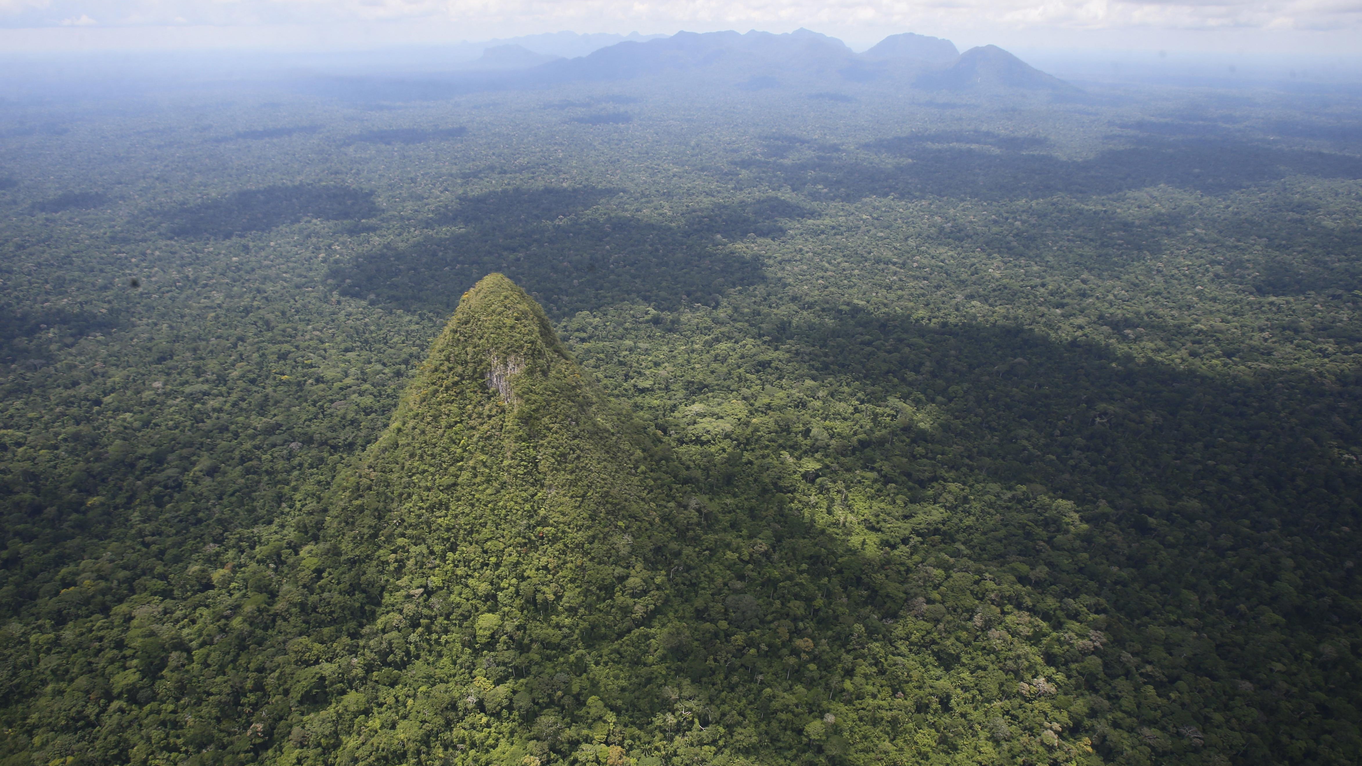
Deep in the Peruvian Amazon, near the border with Brazil, a striking landform has stirred scientific curiosity and cultural reverence alike. Rising abruptly from the dense, flat jungle of Sierra del Divisor National Park, the formation known as Cerro El Cono resembles a near-perfect pyramid — a geometry so precise it has prompted debates among geologists, archaeologists, and Indigenous leaders.
Visible from as far as the Andes Mountains—over 250 miles to the west—El Cono cuts an uncanny figure against the forest canopy. At 1,310 feet (about 400 meters) high, the conical hill appears as an anomaly in a region better known for irregular topography and lush, undisturbed rainforest. While some scientists suggest it’s an ancient volcanic remnant, others point to erosion or even long-lost human architecture.

The peak, long recognized by local Indigenous groups as a sacred entity, sits within a conservation hotspot that also faces persistent threats from illegal logging, mining, and coca cultivation. Despite its protection under Peruvian law since 2015, Sierra del Divisor remains at risk — making El Cono both a symbol of ecological mystery and a frontline in Amazon preservation.
A Geological Puzzle in the Heart of the Amazon
El Cono stands alone—literally. Unlike other peaks in the Sierra del Divisor range, which is part of a rare mountainous formation in the lowland Amazon, this hill has no neighboring ridgelines or foothills. Its smooth, symmetrical slopes have prompted some to describe it as “the Alpamayo of the Amazon,” drawing comparisons to the famously pyramid-shaped peak in the Andes.
Geologists remain divided over its origin. One theory posits that El Cono is the weathered core of an extinct volcano—an idea consistent with nearby formations documented by Peru’s Ministry of the Environment and detailed in the region’s UNESCO World Heritage nomination. Others suggest it may be a rare erosional feature, sculpted over millennia by wind and water acting on isolated geological substrates.

A more speculative idea, occasionally circulated in popular media and online forums, suggests that El Cono could be the remnant of a pre-Columbian pyramid buried beneath vegetation and sediment. While there is currently no archaeological evidence to support this hypothesis, and no formal excavation has taken place, the mountain’s almost geometric form has left even some scientists intrigued.
“From satellite imagery, it’s astonishing,” said Dr. Luis Jaime Castillo, an archaeologist and former Peruvian Minister of Culture, in a statement quoted by BBC Mundo. “But nature can surprise us with perfect shapes.”
Sacred Landmark and Conservation Flashpoint
For the Isconahua and other Indigenous communities who live near the Sierra del Divisor region, El Cono is not merely a geological structure—it is a living spirit. In the cosmology of the Andes and Amazon, such peaks are often considered Apus, sacred mountain guardians that connect the earth to the sky.
These cultural interpretations have been passed down through oral traditions and continue to guide local practices. Ceremonial rituals still take place around the base of the mountain, reinforcing a relationship between people and landscape that predates modern statehood.
This connection adds another layer of urgency to conservation efforts. The surrounding Sierra del Divisor National Park spans more than 1.3 million hectares and includes one of the highest concentrations of endemic species in the Amazon. According to a report by Global Conservation, the park stores more than 500 million tons of carbon dioxide—more than half the annual emissions of all passenger vehicles in the United States.

But the area is far from safe. Satellite monitoring by the Monitoring of the Andean Amazon Project (MAAP) has shown continued encroachment by illegal logging roads and coca plantations. These activities not only threaten biodiversity but also increase the risk of disease exposure for Indigenous groups in isolation, including those protected under Peruvian law.
In recent years, Peru’s National Service of Protected Natural Areas (SERNANP) has partnered with the military, local authorities, and NGOs to deploy drone surveillance, high-speed river patrols, and community-led enforcement. While these efforts have shown progress, enforcement remains a challenge in a region accessible only by boat or air.
Scientific Curiosity Meets Ecological Urgency
Despite its isolated location, El Cono is now drawing increasing international attention. A recent feature by Live Science helped amplify interest, especially online, where satellite images of the peak circulate frequently among archaeology and geography enthusiasts.
But researchers caution against letting viral intrigue overshadow the site’s environmental significance. “Whether El Cono is a volcanic relic, an erosional oddity, or just a beautiful accident, its scientific value lies in the broader ecosystem it supports,” said Dr. Sasha Pare, a science writer specializing in South American biodiversity.
Source link


