Invest 93L: Flood Watches In Effect For LA, MS
A tropical disturbance near the northern Gulf Coast only has a small window for development, but poses a threat of flooding rainfall, particularly in Louisiana, regardless.
Happening Now
The tropical disturbance, called “Invest 93L” by the National Hurricane Center, is centered near the northern Gulf Coast, moving westward.
Areas of locally heavy rain have already pushed westward into parts of Louisiana, as the radar image below shows.
A flood advisory was issued early Thursday morning for parts of southeast Louisiana, including Baton Rouge. From 1.5 to 2.5 inches of rain had already fallen in a few areas near and north of Houma and Morgan City, Louisiana, according to the National Weather Service.
(MORE: What Is An ‘Invest’?)

Development Chance Low
Given the rather disheveled appearance of this disturbance, with rather broad, weak low pressure and most of its thunderstorms well west of it, the chances of it becoming a tropical depression prior to moving over land are now quite low.
The NHC expects Invest 93L to move into Louisiana later today, ending whatever low chance of development.

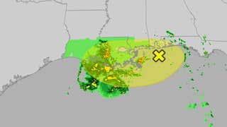
Tropical Development Possible
(The region highlighted is where the National Hurricane Center is watching for tropical development to occur within the next seven days.)
Flooding Rain Threat
The main threat for flooding rain near the Gulf Coast will be Thursday and Friday, though some isolated locally heavy rain may last into Saturday in parts of the lower Mississippi Valley.
The heaviest rain totals are expected along and south of the Interstate 10 corridor from extreme eastern Texas into southern Louisiana, southern Mississippi, southern Alabama and the western Florida Panhandle. Some of those area could pick up over 6 inches of rain through Saturday, with locally heavier amounts where bands of rain repeatedly track over the same area.
The National Weather Service has issued flood watches for all of southern Louisiana and parts of southern Mississippi.
(MORE: What To Do In A Flood)

Jonathan Erdman is a senior meteorologist at weather.com and has been covering national and international weather since 1996. Extreme and bizarre weather are his favorite topics. Reach out to him on Bluesky, X (formerly Twitter) and Facebook.

