MINNEAPOLIS (FOX 9) – In true 2025 fashion, the wildfire smoke has moved out. Now, some heat and plenty of humidity will return to the Upper Midwest, giving us several chances for rain as we head through the next few days.
Rounds of thunderstorms start Friday
What we know:
A frontal boundary will stall over parts of Minnesota and Wisconsin Friday and hang around through the weekend. This frontal boundary will be the focal point for occasional rounds of thunderstorms as several waves pass over it.
With southern winds continually pumping in more moisture, the atmosphere will become water-logged, making any storms that form “efficient rain producers.” It’s these scenarios that can lead to some very high rainfall rates that can often top two inches an hour.
What we don’t know:
Thunderstorms often develop from small localized conditions that are nearly impossible to discover more than a few hours ahead of time, mostly because it’s these localized conditions that form gradually over the few hours prior to initiation. This makes it incredibly difficult to know exactly when or where these storms will occur, and therefore where the heaviest rain may fall.
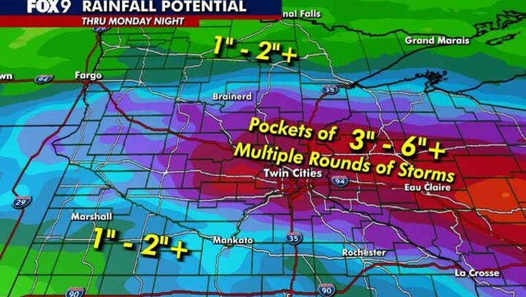
Where will it rain heaviest?
However, as meteorologists, we can recognize the overall pattern that is conducive for these type of events, and can often narrow down a smaller location that has a higher probability for heavy rain. That is what we will be doing in the hours and days ahead to give you as much heads up as possible. For the moment, eastern Minnesota & western Wisconsin have the highest probability for heavy rain over the next three or four days.
Dig deeper:
While it has been a wet few months for some areas, there are spots that have been missed. Here is a look at much of Minnesota & Wisconsin compared to average over the last 120 days, or roughly since the start of the growing season.
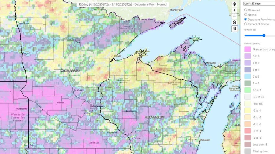
A glaring difference for some areas. For example, the official climate site (MSP Airport) for the Twin Cities is just a quarter inch above average. That’s it! In fact, at my house in Burnsville, I’m almost an inch and a half below average.
But you travel just a few miles to the northwest metro, place like Maple Grove or Plymouth or Rogers, are all more than five inches above average. It’s similar in much of central Minnesota, with many locations easily five inches above average. But there are also areas that could really use some water as you get north and northeast of the Twin Cities toward Lake Superior. Areas from either side of Lake Mille Lacs to much of northern Wisconsin have some pockets that are more than six inches below average. Those are the areas that could handle the most rain over the next few days.
Source link

")
