Tropical Downpours To Impact Florida, Gulf Coast
A rainy disturbance will slide over Florida and into the waters near the northern Gulf Coast over the next couple of days, where there is a small chance it could try to form into a tropical depression before it moves inland.
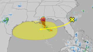
Tropical Development Overview
A stretched out area of low pressure meteorologists call a trough will move over Florida and across the northern Gulf through the end of the week. The disturbance will haul plenty of tropical moisture as it makes that journey, helping to generate numerous showers and storms.
What the National Hurricane Center is watching for is the possibility that converging winds along this so-called trough could help generate a more well-defined area of low pressure that attempts to make a run at forming into a tropical depression or storm. For now, the NHC says there is a low chance of that happening in the waters near and offshore from the northern U.S. Gulf Coast before the disturbance slides inland by this weekend.
The next Atlantic storm name is Dexter.

Impacts Include Rainfall, Rip Currents
Regardless of any attempt at tropical development, this moisture-laden disturbance will generate tropical downpours over the next few days. Below is a look at the latest radar showing where this system is producing rainfall right now.

Current Radar, Watches And Warnings
(Watches and warnings are issued by NOAA.)
Locally, heavy rain could impact areas from Florida westward along the northern Gulf Coast to southeast Louisiana through Thursday morning. The greatest chance of soaking rain will then spread across the northern Gulf Coast to as far west as coastal Texas as the week comes to an end.
Isolated instances of flash flooding might occur in these areas and some storms could contain gusty winds.

If you are planning a beach trip, there will be an increased threat of rip currents to be aware of late this week at beaches from the Florida Panhandle, to Alabama and Mississippi.
There are color-coded flags placed on many beaches each day to communicate the rip current threat. A green flag (low risk) indicates that strong rip currents are not likely. A yellow flag (moderate risk) means that there is a good chance for strong rip currents and a red flag (high risk) signals that strong rip currents are expected and you should stay out of the ocean
You can also go to this link for the latest rip current forecast.
Chris Dolce has been a senior digital meteorologist with weather.com for 15 years after beginning his career with The Weather Channel in the early 2000s.
Source link
 Is Replacing Small Engines on over 300 Planes due to Toxic Fumes")

