A nor’easter is set to hit Boston during what’s always a busy holiday weekend for fall weather activities in New England.
Tens of thousands flock up north for the amazing hiking and fall foliage. The local farms will be buzzing with apple and pumpkin pickers. It is also a popular weekend for folks to shut down their lake homes and secure their boats for the upcoming winter.
The entire weekend will not be a washout, however.
If you look at a satellite or radar image Thursday of the United States, you won’t see much. In fact, you could literally drive for thousands of miles to the south or west and not hit a drop of rain. Currently, there is a large area of high pressure moving down from Canada. This is responsible for the chill in the air and also for the clear, blue skies that stretch for hundreds of miles in every direction.
Tracking the nor’easter
So where is this supposed nor’easter?
For that we need to look about 1,500 miles from Boston, all the way down in western Cuba. The cold front that brought the rain Thursday extends all that through the western Caribbean and a little wave of low pressure is forming at the tail end of that front, south of Florida.
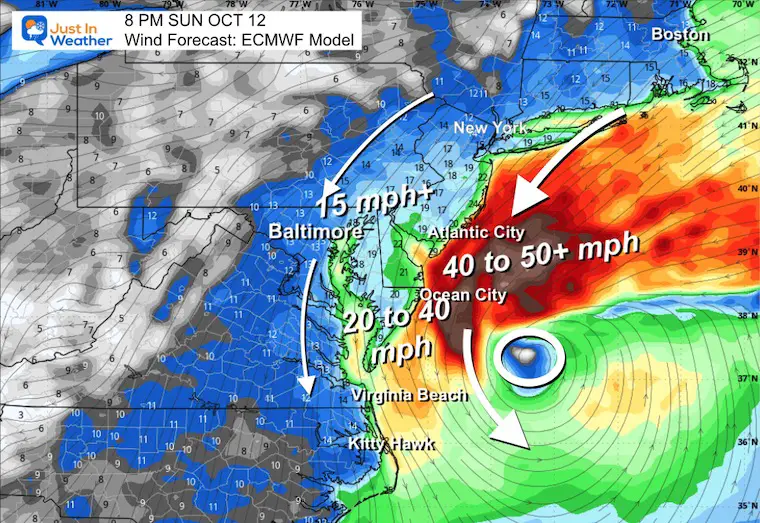
Over the coming days, this will lift northward and strengthen into a sizable coastal storm riding just off the U.S. East Coast.
Boston nor’easter timeline
Saturday: This will be the pick of the holiday weekend here in New England. We will see a good deal of sunshine with just some high cirrus clouds arriving later in the day.
Meanwhile, the coastal storm will be gaining strength off the southeast U.S. coast, lashing the Carolinas with a windswept rain.
Sunday: We should start the day off dry, albeit with increasing cloudiness.
Rain and wind will blanket the coastline from North Carolina through the Mid-Atlantic and Long Island.
That shield of rain will push northward, into southern New England, during the day on Sunday.
If you want to increase your odds of staying dry on Sunday, head north. Central and northern New England should be rain-free for most of, if not all the daylight hours on Sunday.
The farther south you go, the earlier the rain arrives and the wetter you get.
CBS Boston
The winds will also gradually increase on Sunday. By sunset, we expect east-northeast gusts of 25-40 mph across southeastern Mass.
Monday: Almost certain to be the wettest day of the weekend. Monday has the potential to be a windswept washout.
CBS Boston
We still expect the heaviest rain to be in areas farthest south, however, showers are likely to extend as far as northern New England as well.
The winds will peak on Monday, gusting 25-45 mph across most of southern New England.
Wind, coastal flooding and rain from nor’easter
Strongest gusts will be located along the immediate coastline and in particular over Cape Cod and the Islands.
Needless to say, lots of leaves will be flying off the trees this weekend.
CBS Boston
With 2-3 days of onshore winds, there are likely to be pockets of minor coastal flooding. Thankfully, the tides will be lowering (astronomically) off their peak from the king tides this past week. If you live along the coast, circle the afternoon high tide on Sunday (around 4 p.m.) and the evening tide on Monday (around 5 p.m.) as times when splashover or minor inundation could occur.
While the timing may not be ideal, this system is likely to bring some much needed, beneficial rainfall to our area.
When all is said and done, there may be a few inches or more of rain in areas south of Boston.
As always, the WBZ NEXT Weather Team will keep you updated and covered throughout the storm. Stick with us on WBZ-TV, CBS News Boston and WBZ.com
Source link


